![]()
![]()
|
|
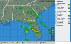
Local Radar provides many tools for working with weather maps.
Radar frames update every five minutes.
Select AutoRefresh to automatically update weather map layer data.

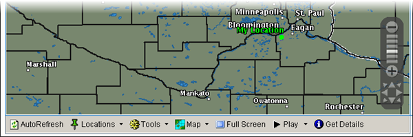
Select Locations

to expand the tool list.

To add locations from the Radar map, select Locations > Add Location

then click on the map where you want to add a location.

When the popup window appears, enter the required information and click OK.

Once added, the city name is highlighted and you can view the Details.

When the page is refreshed, the new location will display in the Location list.

See Locations to learn more about managing your Locations list.
To manage your locations list, select Locations > Edit Locations.

See Locations to learn more about managing your Locations list.
To quickly access another location, select it from the locations drop down list.
|
|
|
See Locations to learn more about managing your Locations list.
Select Tools

to expand the tool list.

Measure distance and direction between two points.
Select Tools > Distance

then click on the map to enter the first point.

Click again to enter the second point and read the distance and direction.

Display range rings around a selected point.
Select Tools > Range Ring

then click on the map to view the range.

Starting with the innermost ring, the range shown is:
|
Zoom Level |
Close |
Middle |
Far |
|
Regional |
50 |
100 |
150 |
|
Subregional |
10 |
25 |
50 |
|
Metro |
5 |
10 |
15 |
Range rings are not available at the national zoom level.
Click Range Ring again to turn it off.
Select Map

to expand the tool list.

Select Map > Add Favorite to add the current (customized) map to My Favorites.


The map will be available in Weather > My Favorites.

To remove the current map from My Favorites, select Map > Remove Favorite.

To learn more about managing your weather favorites, see Weather Favorites.
Select Map > Print to print the current map.

Select Full Screen, to view the map at its maximum size.

If AutoRefresh is on, data will update but animation will not be available during full screen mode.
Click anywhere on the full screen to return to normal viewing.
Click the Play icon to view radar animation.
Select Play

to expand the tool list.

From left to right, the controls perform the following:
To Beginning | Back | Pause | Stop | Forward | To End
Display additional details about data displayed on some layers.
Click Get Details

then hover the mouse over the highlighted location on the map to see the details.
In order to see details for a custom location, you need to add the location to your Locations list.
See Weather Details to learn more about weather radar layers.


Use the Zoom tool to adjust the map view.
To move the zoom tool, click on the tool with the mouse and drag the tool to its new position in the image.

|
|