![]()
![]()
|
|
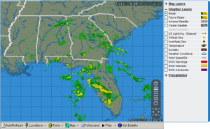
From Local Radar select Get Details

to display additional details about data displayed on some layers.
Additional data appears as the mouse hovers over active map locations.
|
Official and Unofficial Observation Temperature Humidity Weather Conditions Wind Speed-Direction |
|
|
No additional information is available for the following: |
|
|
Radar Future Radar Intrared Satellite Visible Satellite Storm Corridors U.S. Lightning-Delayed Precipitation |
Interstates Highways Railroads County Lines Topography |
|
|
|
|
Station |
City name for the location as assigned by Meteorlogix or the name of the weather observation site. |
|
Valid Time |
Time and date the observation was taken. |
|
Temperature |
Current temperature in Fahrenheit. |
|
Dew Point |
Current dew point in Fahrenheit. |
|
Relative Humidity |
Current relative humidity in percent. |
|
Visibility |
Current visibility in miles. |
|
Clouds |
Sky coverage and height of clouds above ground level. |
|
Winds |
Direction wind is coming from and speed in miles per hour. |
|
Barometric Pressure |
Current atmospheric pressure reduced to sea level in millibars. |
|
Weather Condition |
Current general weather or sky conditions observed at the site. |
|
|
|
|
Storm ID |
The identifier for the radar that detected the storm and the storm identifier provided by NEXRAD. |
|
Location |
Latitude and longitude of the center of the storm. |
|
Valid Time |
Time and date the storm cell was detected. |
|
Direction |
Direction the storm is moving towards. |
|
Speed |
Rate the storm is moving (in miles per hour). |
|
Storm Top |
Height, in feet, of the storm top. |
|
Maximum dBZ Level |
Highest reflectivity value detected in the storm cell. |
|
Vertically Integrated Liquid |
Value of the actual liquid water detected in the storm based on drop size and reflectivity. Higher values indicate an increased likelihood of hail. |
|
Storm Activity |
Indicates if hail, a mesocyclone, or TVS has been detected in the storm. |
|
Probability of Hail |
Percent chance that hail is occurring in the storm. |
|
Probability of Severe Hail |
Percent chance that hail greater than 3/4 inch is occurring in the storm. |
|
Maximum Expected Hail Size |
Size, in inches, of the largest hail falling from the storm. |


|
|
|


|
Name |
Name of the airport. |
|
ID |
Three or four character identifier for the airport. |
|
Latitude |
Latitude of the airport. |
|
Longitude |
Longitude of the airport. |
|
Mag. Variation |
Magnetic deviation from true north at the airport. |
|
Elevation |
Height of the airport above sea level. |
|
|